Driving the G318 — the Sichuan–Tibet highway explained
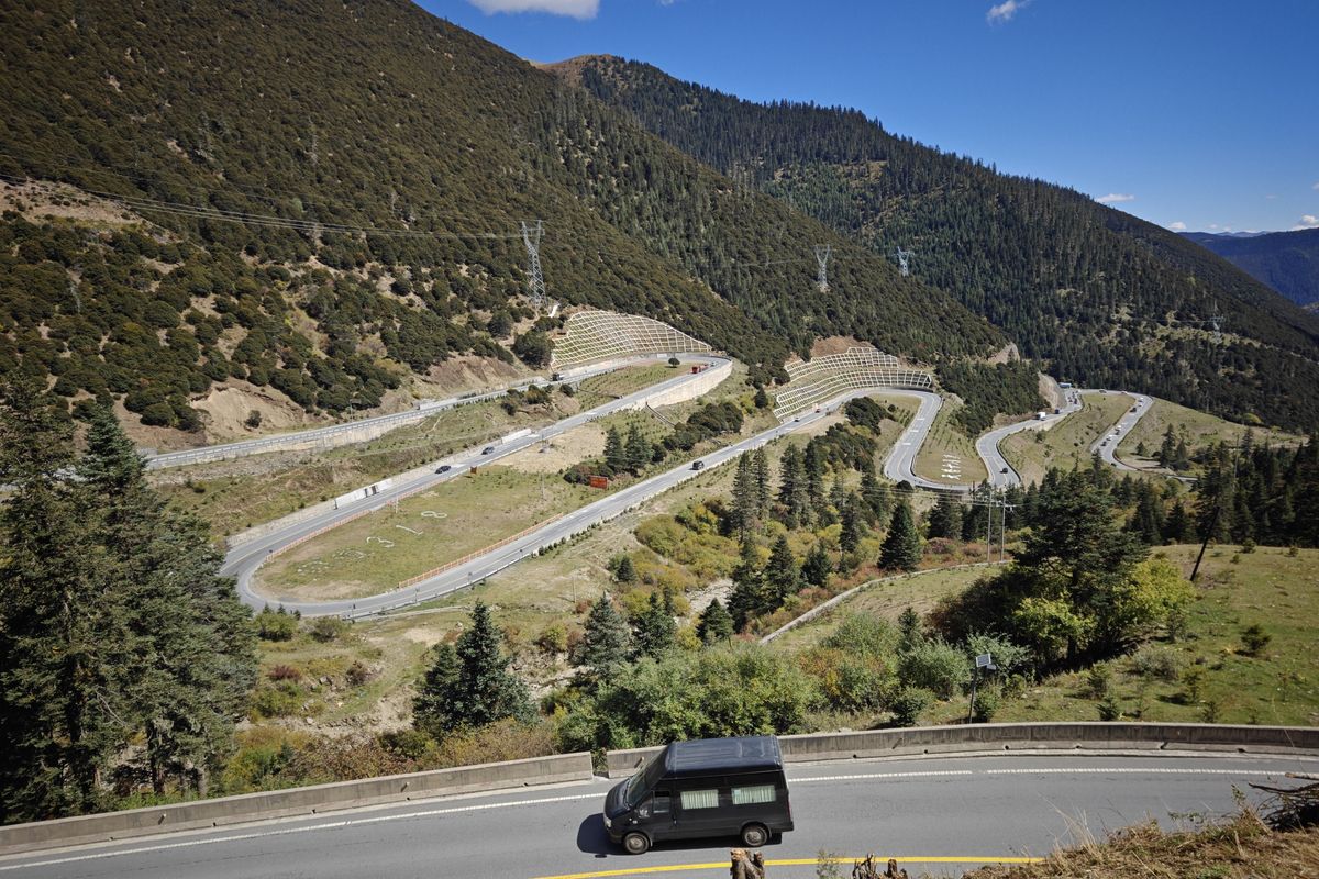
The G318 is the most famous road in China: 2,100 km from Chengdu to Lhasa, over passes above 4,000 m. This is the part we actually drive, and what has changed since the tunnels arrived.
The road in one paragraph
The G318 runs the width of China, from Shanghai to the Nepal border. The stretch travellers mean when they say "the G318" is the Sichuan–Tibet southern line: roughly 2,100 km from Chengdu to Lhasa, climbing from the Sichuan basin onto the Tibetan plateau and over a chain of passes above 4,000 m.
A Chengdu-based trip covers the eastern half of it — the part inside Sichuan — and that is the stretch where the scenery changes fastest: from warm river towns to alpine grassland to bare high plateau in the space of a few days.
The Sichuan section, pass by pass
The classic progression east to west. The altitudes are the thing to watch: the road spends most of its time high, and the towns sit low in the valleys between the passes.
| Place | Altitude | Note |
|---|---|---|
| Luding (泸定) | 1,330 m | The Dadu River gorge and the old iron bridge |
| Kangding (康定) | 2,560 m | The gateway town; sleep here on night one |
| Zheduo Pass (折多山) | 4,298 m | The first pass above 4,000 m — the real test |
| Xinduqiao (新都桥) | 3,300 m | "Photographer's paradise"; poplar and Tibetan houses |
| Yajiang (雅江) | 2,600 m | A good low place to sleep |
| Litang (理塘) | 4,014 m | The "high city" — avoid sleeping here on day one |
| Kazila Pass (卡子拉山) | 4,718 m | One of the highest points on the Sichuan stretch |
| Batang (巴塘) | 2,580 m | Last Sichuan town before the Tibet border |
How the road has changed
The G318 today is not the road of the old travelogues. A string of tunnels — Erlangshan, Goloshan, Jianziwan and others — now bypasses the highest passes, so a drive that once climbed over every ridge now dives under several of them.
That is mostly good news: faster, safer and open more of the year. The cost is that some of the famous viewpoints now sit on the old, abandoned road above the tunnel mouth. If a view matters to you, ask your driver to take the old pass road where it still exists — several are still drivable in good weather.
Drive it yourself or hire a driver?
Self-driving the G318 as a foreign visitor means a Chinese-recognised licence, a registered rental, and insurance that actually covers mountain roads. The driving itself is not hard — the road is paved throughout — but it is long, high and busy with trucks, and a flat tyre at 4,700 m is a different problem from one near town.
What we do is put a driver who knows the road, the altitude and the stops behind the wheel, and keep the itinerary flexible. That is not a sales line — it is the honest trade-off for a road where the point is to look at it, not to manage it.
Altitude and where to sleep
The rule that makes the trip comfortable: climb high, sleep low. Kangding, Yajiang and Batang all sit under 2,900 m, and those are the towns to spend the night in. Litang at 4,014 m is a highlight to see, not a first night to sleep through.
Acclimatise for a night in Kangding before crossing Zheduo Pass, and the rest of the route is far easier on the body.
When to go, and the weather
May to June and September to October are the dependable windows: clear air, green or golden scenery, and passes reliably open. July and August are the rainy season, when the landslide risk on the gorge sections is highest. Winter brings ice on the passes and some of the tunnels' approach roads close in bad weather.
Avoid the Chinese national holidays in early May and October if you can — the road and every stop fill to capacity.
In this guide
Do I need a permit to drive the Sichuan section?
+
No. As long as your trip stays inside Sichuan, you need only a valid China visa. The Tibet Travel Permit is required only if you continue west of the border into Tibet itself.
How long does Chengdu to Lhasa take overland?
+
Six to ten days at a sane pace. We recommend spending the Sichuan section slowly rather than racing to the border — that is where the scenery is densest.
Is the road safe?
+
The road is fully paved and well used, but it is high, winding and shared with heavy trucks. Drive by daylight, not by schedule, and let the weather — not the itinerary — decide the day.
Keep reading
Have a question we have not answered?
Message us on WhatsApp and a real person will reply — usually within a few hours.
Ask us on WhatsApp